Upcoming Frost Could Threat Early Bud Break Cultivars
go.ncsu.edu/readext?856239
en Español / em Português
El inglés es el idioma de control de esta página. En la medida en que haya algún conflicto entre la traducción al inglés y la traducción, el inglés prevalece.
Al hacer clic en el enlace de traducción se activa un servicio de traducción gratuito para convertir la página al español. Al igual que con cualquier traducción por Internet, la conversión no es sensible al contexto y puede que no traduzca el texto en su significado original. NC State Extension no garantiza la exactitud del texto traducido. Por favor, tenga en cuenta que algunas aplicaciones y/o servicios pueden no funcionar como se espera cuando se traducen.
Português
Inglês é o idioma de controle desta página. Na medida que haja algum conflito entre o texto original em Inglês e a tradução, o Inglês prevalece.
Ao clicar no link de tradução, um serviço gratuito de tradução será ativado para converter a página para o Português. Como em qualquer tradução pela internet, a conversão não é sensivel ao contexto e pode não ocorrer a tradução para o significado orginal. O serviço de Extensão da Carolina do Norte (NC State Extension) não garante a exatidão do texto traduzido. Por favor, observe que algumas funções ou serviços podem não funcionar como esperado após a tradução.
English
English is the controlling language of this page. To the extent there is any conflict between the English text and the translation, English controls.
Clicking on the translation link activates a free translation service to convert the page to Spanish. As with any Internet translation, the conversion is not context-sensitive and may not translate the text to its original meaning. NC State Extension does not guarantee the accuracy of the translated text. Please note that some applications and/or services may not function as expected when translated.
Collapse ▲AWIS Weather Advisory: Frost Threat late weekend, early next week.
In collaboration with AWIS Weather Services
Dear all,
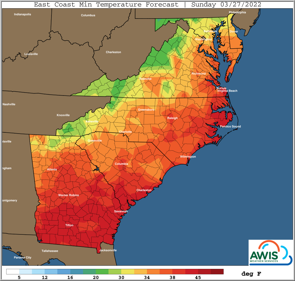
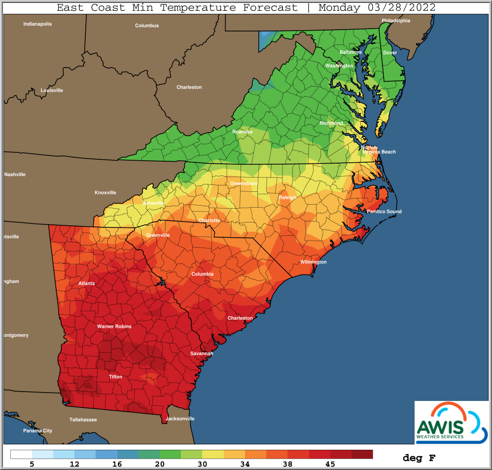
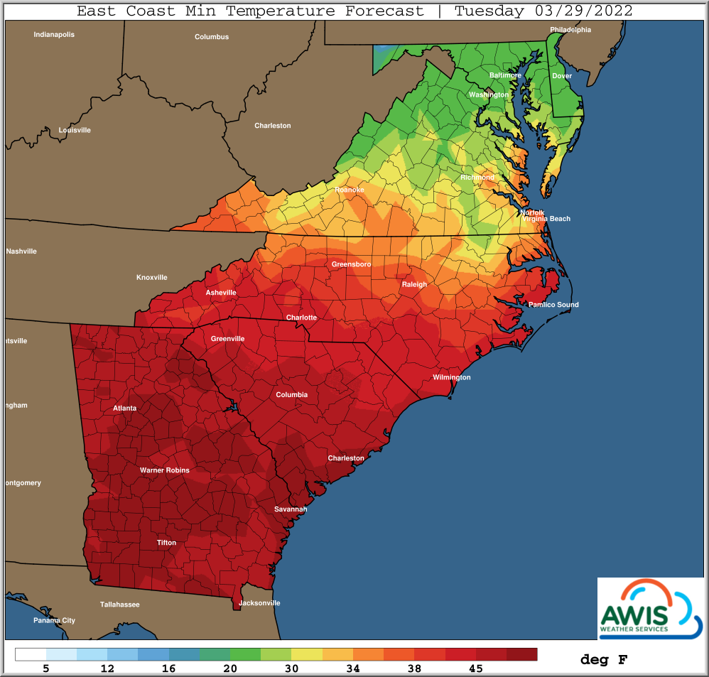
Frost is very likely in the central and western parts of North Carolina and most of Virginia, coming Sun to Tue, with a high likelihood on Monday Morning (see Fig 1). In some areas, early bud breaking cultivar are in bud swell already. While this is very early in the season, the upcoming frost will be a threat on some cultivars, especially for Chardonnay in the Yadkin Valley!
Wind machines most likely will not work, since larger airmasses are causing the predicted cold temperatures. We recommend to use overhead sprinkler systems (if you have them) to save some of your primary bud. Please see this publication for more details on cold management in grapes.
Since every cold protection method inherits some risk, we recommend to only think of cold protection if you are more than 10% into bud swell!
If you have implemented delayed winter spur pruning on your early cultivars, do not implement the final prune until after the frost event. Delayed winter spur pruning is the best tool to delay bud break, and often useful to avoid early spring frost damages.
General Discussion
*** Low Rain Chances Through Weekend, Some winds
*** Freeze and/or Frost Risks Some Areas Sun-Tue Mornings
*** Freeze/Frost Threat Greatest Monday Morning, Carolinas’ Northward
*** Perhaps Frost Threat Tuesday Morning Northern/Eastern Areas
*** Warmer Middle / End Of Next Week
*** Next Rain Chances Not Until Late Next Week
A couple weaker disturbances will move SE through
the main upper trough, but will not produce much if any rainfall
Friday into the weekend, just mostly periods of clouds and
variable winds, along with cooler temperatures.
The last weak disturbance will push SE through the Mid-Atlantic
and SE states on Saturday, with the coldest air behind this
for late this weekend into early next week.
Growers need to be ready for a potential freeze as early
as Sunday morning some areas. This affects mainly parts of Western NC, VA and North. Most likely a potential freeze and/or frost will be
next Monday morning.
A frost or light ground freeze could linger into Tuesday
morning, mainly far Eastern and Northern areas of the
Mid-Atlantic.
Min Temp Maps
Fig 1. Minimum Temperatures for the Region from Sunday 3/27/2022 to Tuesday, 3/29/2022. The highest frost threat for NC will be the night from Sunday to Monday.
At the moment it looks like especially regions on the Yadkin Valley and other more southern regions on a similar or lower elevation levels will see potential impacts on early bud breaking cultivars such as Chardonnay. If you are more than 10% into bud swell, and you don’t have protection methods at hand, we recommend to assess bud cold damage several days after the event, according to this publication.


