AWIS Weather Forecast: Frost Risk April 22-23
go.ncsu.edu/readext?791136
en Español / em Português
El inglés es el idioma de control de esta página. En la medida en que haya algún conflicto entre la traducción al inglés y la traducción, el inglés prevalece.
Al hacer clic en el enlace de traducción se activa un servicio de traducción gratuito para convertir la página al español. Al igual que con cualquier traducción por Internet, la conversión no es sensible al contexto y puede que no traduzca el texto en su significado original. NC State Extension no garantiza la exactitud del texto traducido. Por favor, tenga en cuenta que algunas aplicaciones y/o servicios pueden no funcionar como se espera cuando se traducen.
Português
Inglês é o idioma de controle desta página. Na medida que haja algum conflito entre o texto original em Inglês e a tradução, o Inglês prevalece.
Ao clicar no link de tradução, um serviço gratuito de tradução será ativado para converter a página para o Português. Como em qualquer tradução pela internet, a conversão não é sensivel ao contexto e pode não ocorrer a tradução para o significado orginal. O serviço de Extensão da Carolina do Norte (NC State Extension) não garante a exatidão do texto traduzido. Por favor, observe que algumas funções ou serviços podem não funcionar como esperado após a tradução.
English
English is the controlling language of this page. To the extent there is any conflict between the English text and the translation, English controls.
Clicking on the translation link activates a free translation service to convert the page to Spanish. As with any Internet translation, the conversion is not context-sensitive and may not translate the text to its original meaning. NC State Extension does not guarantee the accuracy of the translated text. Please note that some applications and/or services may not function as expected when translated.
Collapse ▲AWIS Weather Forecast: Frost Risk April 22-23
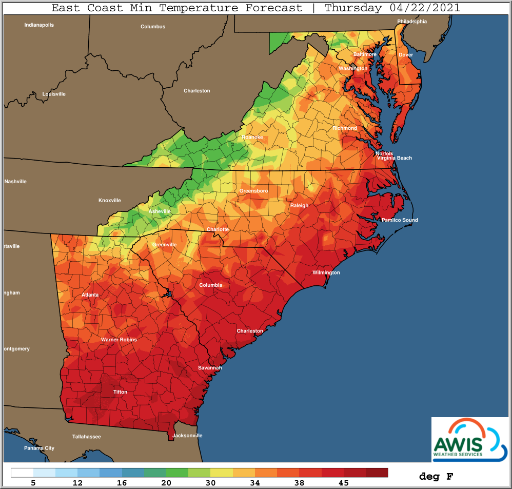
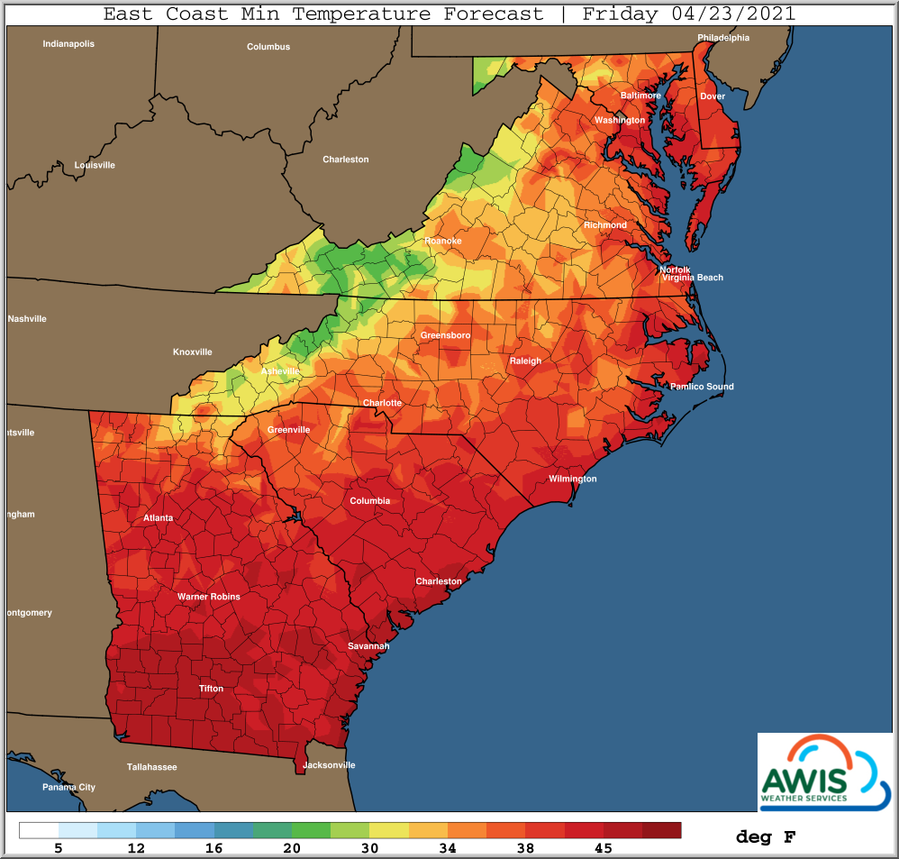
A wider frost- and freeze risk for North Carolina and the Mid-Atlantic (Figure 1) is predicted for coming Thursday and Friday. There is an increased risk of bud and shoot damage, especially in the Foothills and parts of the Yadkin Valley.
Please read our new publication on Prevention and Management of Frost Injury in Wine Grapes.
General Weather Discussion
A broad upper level low pressure trough will continue across the Eastern 1/2 of the USA into the weekend.
Multiple weaker disturbances and associated frontal boundaries will move through this upper level trough from both the NW and W/SW over the next couple days. This makes timing of clouds and winds a little more difficult than even normal, particularly from North Carolina through the Mid-Atlantic. The next strongest disturbance and associated frontal boundary will move through the area late Tuesday night through early Wednesday afternoon. Gusty south winds of 10-20 ahead of front, turning to West then NW behind the front later Wednesday into early Wednesday evening. Not a lot of rain is expected with this system, but local totals of 1/4 inch or more, mainly Mid Atlantic Region.
Frost and freeze potential Thursday morning greatest across the Southern Appalachians and foothills, with frost into the Piedmont areas of Northern South Carolina into Central NC. Areas further to the Northeast and closer to the Atlantic may have more clouds and wind to help limit frost and/or freezing temperatures.
Larger areas from the Northern Interior Southeast to the Interior Mid Atlantic will have frost and/or freeze risks on Friday morning. Winds will be lighter most areas Friday morning, allowing radiational conditions to take hold with ground temperatures 3-6 degrees colder in some areas than temperatures normally taken at the 5 foot levels. Clouds will also be less prevalent many areas later Thursday night through sunrise Friday morning.
Min. Temperature Forecasts
Figure 1: Minimum Temperatures forecasts for the region on Thursday (04/22/2021) and Friday (04/23/2021). With winds declining, frost risks are given in the North Carolina mountains, foothills, and Piedmont especially at the mornings of both days (provided by AWIS Weather Services.)
Please find your local weather forecast below under “hourly forecast.”
Winds are supposed to slow down on Thursday morning, increasing the risk of frost significantly. However, wind gusts on Thursday might still affect the efficacy of frost protection measures such as sprinkler systems or wind machines. We will keep you informed as the situation unfolds. Please read: Prevention and Management of Frost Injury in Wine Grapes.
Hourly Forecast
(provided by AWIS Weather Services)
North Carolina:
South Carolina:
Georgia:
Virginia:
Maryland:
This post was created under the consultation and with permission of AWIS Weather Services.


