AWIS Weather Forecast 8/4/2021
go.ncsu.edu/readext?813195
en Español / em Português
El inglés es el idioma de control de esta página. En la medida en que haya algún conflicto entre la traducción al inglés y la traducción, el inglés prevalece.
Al hacer clic en el enlace de traducción se activa un servicio de traducción gratuito para convertir la página al español. Al igual que con cualquier traducción por Internet, la conversión no es sensible al contexto y puede que no traduzca el texto en su significado original. NC State Extension no garantiza la exactitud del texto traducido. Por favor, tenga en cuenta que algunas aplicaciones y/o servicios pueden no funcionar como se espera cuando se traducen.
Português
Inglês é o idioma de controle desta página. Na medida que haja algum conflito entre o texto original em Inglês e a tradução, o Inglês prevalece.
Ao clicar no link de tradução, um serviço gratuito de tradução será ativado para converter a página para o Português. Como em qualquer tradução pela internet, a conversão não é sensivel ao contexto e pode não ocorrer a tradução para o significado orginal. O serviço de Extensão da Carolina do Norte (NC State Extension) não garante a exatidão do texto traduzido. Por favor, observe que algumas funções ou serviços podem não funcionar como esperado após a tradução.
English
English is the controlling language of this page. To the extent there is any conflict between the English text and the translation, English controls.
Clicking on the translation link activates a free translation service to convert the page to Spanish. As with any Internet translation, the conversion is not context-sensitive and may not translate the text to its original meaning. NC State Extension does not guarantee the accuracy of the translated text. Please note that some applications and/or services may not function as expected when translated.
Collapse ▲AWIS Weather Forecast 8/4/2021
As we come closer to harvest, weather forecasts become more important. In collaboration with AWIS Weather Service, we cover the next 7 days for North Carolina viticulture regions, including diurnal temperature ranges.
General Weather Discussion
A very slow moving frontal boundary near the Atlantic Coast, combined with an East Coast Upper level trough, has kept it on the wet side recently, mainly over the Eastern Carolina’s to Northeast Florida. One more upper level disturbance will move through the Eastern US late this week, keeping scattered to numerous showers around. Showers will be more scattered next week.
On the temperature side, a warming to near to a little above seasonal levels is expected late this weekend, lasting most of next week. This means maximum temperatures mostly upper 80s to lower 90s, minimums upper 60s to lower 70s.
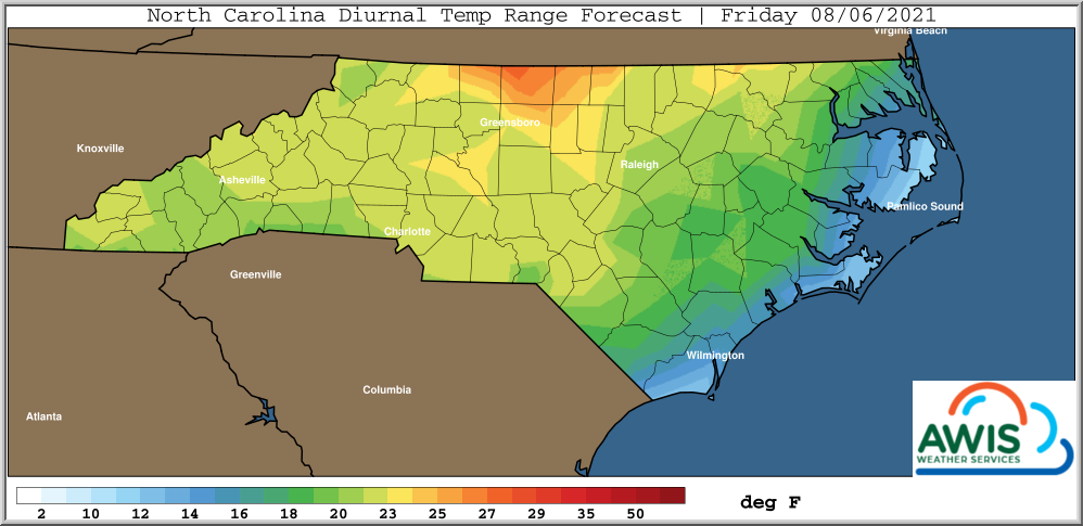
This puts most areas in the 15-20 degree diurnal temperature ranges, 20-25 higher elevations of the Appalachians.
Looking further ahead, there are signs that the latter half of August will trend to a more frequent wetter and cooler period. For now, no immediate tropical threat is indicated into next week. But will be watching a weak system currently in the mid-far Southern Atlantic as it moves West / Northwest into next week.
Diurnal Temperature Ranges
Diurnal temperature ranges are important for ripening. Over the next 7 days, highest levels of diurnal temperature will exceed 25 F and will be seen in the Yadkin Valley AVA and neighboring counties from Thursday to Friday, 8/6/2021 (Figure 1).
Figure 1: Predicted diurnal temperature ranges for Thursday-Friday, 8/6/2021.